The extraordinary warmth that first enveloped the planet last summer continues strongly into 2024: Last month was the warmest January on record, the European Union’s climate watchdog announced Thursday.
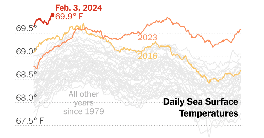
It was the warmest January on record for the oceans as well, according to the European Union’s Copernicus Climate Change Agency. Sea surface temperatures were slightly lower than August 2023, the warmest ocean month. And sea temperatures continued to rise in the early days of February, surpassing daily records set last August.
The oceans absorb the vast majority of extra heat that greenhouse gases trap in the atmosphere near the Earth’s surface, making them a reliable gauge of how much and how fast we’re warming the planet. Warmer oceans provide more fuel for hurricanes and atmospheric river storms and can disrupt marine life.
January makes it eight consecutive months that average air temperatures, both on the continents and in the seas, have exceeded all previous records for the time of year. Overall, 2023 was Earth’s warmest year in a century and a half.
The main driver of all this warmth is no mystery to scientists: Burning fossil fuels, deforestation and other human activities have driven the mercury steadily upward for more than a century. The current El Niño weather cycle also allows more ocean heat to be released into the atmosphere.
However, exactly why the Earth has been so hot, for so long, in recent months remains a matter of debate among researchers, who are waiting for more data to come in to see if other, less predictable and perhaps less understood factors may also be at play. work around the margins.
“Rapid reductions in greenhouse gas emissions are the only way to stop global warming,” Samantha Burgess, deputy director of Copernicus, said in a statement.
According to the Copernicus data, January temperatures were well above average in eastern Canada, northwest Africa, the Middle East and Central Asia, although much of the inland United States was colder than usual. Parts of South America have been warmer than normal and dry, contributing to the recent forest fires that have ravaged central Chile.
The intensity of recent underwater heat waves prompted the National Oceanic and Atmospheric Administration in December to add three new levels to its ocean heat alert system to show where corals may be bleaching or dying.
An El Niño pattern like the one currently seen in the Pacific is associated with warmer years for the planet, as well as a range of effects on rainfall and temperatures in specific regions.
But as humans warm the planet, the effects that meteorologists could once confidently expect El Niño to have on local temperatures are no longer as predictable, said Michelle L’Heureux, a NOAA scientist who studies El Niño. and its opposite phase, La Niña.
“For areas that previously tended to have below-average temperatures during El Niño, you almost never see that anymore,” Ms L’Heureux said. “You see something that is closer to the average, or even leaning above the average.”

